 Industries and their partners are operating sites worldwide and need to manage a large number of processes along the value chain. There is an emerging demand for positioning and localization services resulting from the IoT services and digitalization ambitions of industries. The automated identification and localization of objects in indoor- and outdoor campus areas is the key enabler for more process transparency, optimizations, and future and extended use-cases like automated guided vehicles or others. Existing positioning solutions are designed for specific use-cases like GPS for outdoors, and individualized technologies for indoors but cannot fulfill the industry requirements in the context of connectivity, precision, flexibility, cost, and standardization. Oftentimes, several systems, solutions, and specialists are needed for different use-cases.
The Campus Positioning of T-Systems and its components focus on combining different localization technologies like mobile cellular technology and complementary technologies like UWB, BLE, RFID, GPS, WIFI… into one solution serving all planned process steps digitalized in different indoor- and outdoor zones of the campus in scope. It provides connectors to existing common real-time-localization systems and uses the state-of-the-art real-time 5G capabilities to automatically localize moving and non-moving objects in order to serve the following use-cases within various industries:
- Geofencing in order to trigger area of interests (zones), entries, and leaving events,
- Track and Trace for automatically capturing object movements,
- GatesRecognition for automatically capturing passing events,
- Presence Monitoring for automatically detecting if an area of interests is occupied or not,
- Utilization and KPI calculation for campus areas of interests,
- Generation of alarms and notifications based on predefined rulesets,
- Widgets for visualization of assets and asset movements in real-time,
- Widgets for visualization of asset tracks and results of motion analysis.
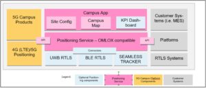
 The Positioning Service is the main component of the Campus Positioning product, providing functions and connectors for the integration of different localization technologies. Furthermore, it provides a standardized API for the integrating of customer systems and 5G campus components.
The Positioning Service is fully compatible with omlox, the new industry standard for Industry 4.0 location-based services defining the interfaces between movable assets, the localization infrastructure, their coordinates, and the data-consuming business applications.
 The connectors and API are based on omlox, the first open and independent industry standard for localization services. omlox is an open and interoperable standard that is revolutionizing real-time locating. Driven by an industry consortium of major players, omlox ensures seamless positioning services across multiple established or even upcoming technologies (ex. UWB, Wi-Fi, GPS, 5G, RFID, and BLE). All location-based use-cases are being supported. The omlox compatible service is basically built upon two core elements, open infrastructure, and a lightweight software middleware, supporting unified access to positioning data from various sources and various technologies. omlox is ready to support multiple transmission technologies like UWB and 5G at the same time right out of the box. The middleware (omlox Hub) is the central component managing the different campus localization zones using various positioning technologies (i.e., BLE, UWB, 5G) at the same time. It is able to transform all incoming position data into global geo-coordinates, thus being able to, e.g., calculate potential collision between vehicles, load carriers, and other assets. Seamless fencing across multiple data sources becomes a reality.
The service supports different positioning and localization technologies.
- LTE-based localization technology with a precision of up to 5 m.
- UWB as localization method with a precision of up to 10 cm
- GPS based localization method with a precision of up to 10 m
- BLE proximity-based localization with a precision of up to 10 m
With the omlox compatible interfaces, the Positioning Service provides standardized APIs for the simplified, quick, and cost-efficient integration of business applications and the integration of real-time localization systems (i.e., BLE, UWB) and cellular-based localization systems (i.e., LTE, 5G).
- Integration of LTE, 5G based infrastructure
- Integration of RTLS systems based on UWB (later also BLE)
- Integration of GPS tracking devices
